Mauritania
/
Our entry onto the continent of Africa started when we arrived into Tunisia on the ferry from Sicily. After a few weeks exploring the country that is home to Africa’s northernmost point, Cape Angela, we crossed the border into Algeria with an optimistic agenda of not only crossing the largest country in Africa but also crossing the Sahara, the largest desert in the world that extends between 1,300-2,000 km from north to south and around 5,000 km from east to west. Our plan was to exit Algeria and enter Mauritania via Tindouf, a new border post that opened in February 2024. Despite having to endure an escort from Algeria’s armed forces for the last 1,600km of our route, everything went according to plan and the Mauritanian Sahara was the final stretch of our epic adventure.

zouerate
After days of desert driving, we arrived at the remote Mauritanian town of Zouerate, a dusty, desolate looking place that turned out to be typical of nearly every town we subsequently drove through. Shabby, brown concrete blocks served as housing, donkeys and carts made up 50% of the traffic, large numbers of goats scavenged through huge piles of trash and 1980’s Mercedes 190’s were having one last gasp before finally dying.
The one thing that set Zouerate apart though, was that it is one end of Mauritania’s iron ore railway where the longest train in the world (3km) runs to the Atlantic port of Nouhadibou and back every day. Already covered in thick brown Saharan dust, the opportunity to add a final layer of black ore dirt - an unavoidable aspect of riding for free on top of one of the 200 ore filled wagons – was one to be missed, and instead we continued south for another 250km to Atar, capital of the Adrar region. This plateau region is surrounded by mountains and desert dunes and contains some of Mauritania’s most visited places and where, for the first time in a long time, we met and interacted with other foreigners. Most were part of tour groups but we did meet a couple of French guys with heavily laden gravel bikes who had cycled all the way from Paris.

iron ore train

inimi desert camp
As addictive as the Sahara had been, travelling solo through such a large, mostly uninhabited wilderness had not been without a constant niggling concern of possible misfortune and the relief on reaching tarmac and people was nearly enough to have us heading straight for the coast and the capital city of Nouakchott. But, feeling that we would be doing Mauritania a dis-service if we just drove through, we made the decision to have one last desert raid east towards the Richat Structure. Prior to setting off we spent the night at Inimi desert camp hoping to find other overlanders interested in making the 3-day trip with us. No such luck, we were the only people there and after purchasing provisions and having our route confirmed by a basic map drawn in the sand we headed off once again on our own.

stuck
It was relatively easy to find our way as we made slow progress over rocky tracks and corrugated dirt roads before arriving at the rolling dunes that we would have to cross to continue. How much more fun would this be with a couple of companion vehicles we thought, as we reduced the tyre pressure and the the familiar concerns about getting stuck or having a mechanical breakdown resurfaced. For once, someone was listening as suddenly, just in front of us, an assorted group of French 4x4 vehicles appeared. We had seen similar groups in Tunisia where individuals and their vehicles come together for a multi-day desert adventure with varying levels of support provided by local guides. This group appeared to be on the budget option as whilst most of them were stuck in a wide soft basin of sand their guides in a couple of Toyota pick-ups were sat across from the basin taking advantage of some down time. Keen not to become another stranded vehicle, we upped the revs and Bob just about managed to get to the other side without succumbing to the same fate. Too polite to just drive off, or perhaps keen for some company, we pitched in with shovelling sand and laying down max tracks until everyone had made it onto firmer ground. It’s a tedious business moving sand, especially without a common language and by the time we’d finished we decided that perhaps we were better off on our own and left them to it.


The first place we came to was Chinguetti, an ancient town known as the City of Libraries. Founded in the 13th century as a caravan trade hub connecting west and north Africa, it became a major centre for Islamic scholarship. Thousands of medieval manuscripts on a range of subjects including mathematics, astronomy and poetry are housed in private family-owned collections within traditional stone and mud-brick houses. There was also a tiny museum in situ with a fascinating collection of artefacts and tools which provided an intriguing glimpse of nomadic life and caravan trading along the Saharan trade routes.
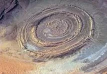
richat structure - eye of the sahara
As interesting as Chinguetti was, our main objective was further east; the Eye of the Sahara, also known as the Richat Structure. An eroded geological dome 40km wide that when viewed from space looks like a giant bullseye or spiral. Initially thought to be an impact crater, it is now believed to be a geological uplift caused by volcanic activity, erosion of sedimentary rock and weathering and aside from some references to the Lost City of Atlantic, it remains one of the most unique geological formations on earth. It took us two days to get there and although we hiked into its centre, the structure was so vast that even with the drone it wasn’t possible to get high enough above it to appreciate the massive concentric rock rings.
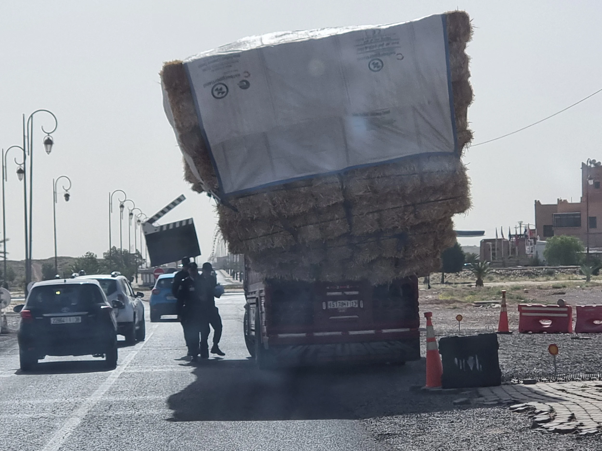
Not wanting to run the gauntlet of the dunes again, we picked out an alternative route back to Atar. It’s hard to know what’s worse, solo soft sand driving or 200km of some of the worst corrugations we have ever driven over. Feeling as if we had just been through the spin cycle of a commercial washer, we eventually made it back to Atar and if we had been undecided before we now had no compunction at all in sticking to the tarmac and getting a shift on to the coast. What should have been a straight-forward drive of around 600 km wasn’t without its frustrations as we were halted at every single one of the 18 police checkpoints, each one requesting a fische containing full information on us and Bob. Fortunately, this zealous approach to keeping tabs on foreigners has been well posted on social media and we had a huge stack of DIY forms that once produced enabled us to move quickly on.
Overlanding full time is perhaps not the best environment for a rigid schedule and on reaching Nouakchott, the realisation that the Canary Islands was less than a 2-hour flight away, was an excellent opportunity to exercise some flexibility. Briefly checking into the only decent hotel in town we threw the necessary into our rucksacks and leaving Bob under the watchful eye of hotel security boarded the next plane out.

cnary islands - mountainous interior
The Canaries belong to Spain and are a group of 7 volcanic islands in the Atlantic Sea. Of course we wanted some pleasures from the western world, but we were also desperate to stretch our legs after weeks of being confined in Bob’s cramped front seats. The GR131 is a multi-day trail that crosses all the islands utilising ferries from one island to the next, and feeling a bit like truanting school children we spent the next 10 days hiking the sections on Gran Canaria and Tenerife. It was the perfect respite following our crossing of northern Africa. We chilled out at small beach cafes savouring ice-cold beers; discovered the local guachinches (family-run eateries) offering up fresh grilled fish and a glass of local Malvasian volcanic wine; strolled along litter-free cobblestone streets whilst listening to the local buskers and explored the scenic mountainous interiors.
On our return to Nouakchott, Ramadan was taking place and the overcrowded and chaotic streets that we had left were somewhat more manageable although just as unappealing. Rising from the desert like a mirage, this relatively new City is often ranked among the world’s most difficult cities to live in, not because of outright hostility or war, but due to harsh environmental conditions. It is at the mercy of the Sahara and the Atlantic Ocean with frequent sandstorms ensuring that everything is permanently covered in a fine layer of dust. It is one of the poorest countries in the world with high unemployment and a stark wealth gap; whilst a small elite lives in walled villas, much of the population struggles in makeshift homes surviving by selling goods on the street, driving decrepid taxis, fishing or begging. With next to no waste management, there is putrifying garbage everywhere and this, combined with a lack of drainage systems, permeates the city with a persistent unpleasant hum.

Port de Peche
Taking a few deep breaths of hotel air-conditioning we headed out to have a look around which, with limited highlights, fortunately didn’t take long. The main attraction was Port de Peche, a large fishermen port and fish market, where the daily catch includes thousands of kilos of bream, seabass, grouper, sole, lobster, sardines, crabs and mullet. The fish are brought into shore by traditional, colourful pirogues (long wooden boats) and hauled over the sandy beach by teams of fishermen, many of whom have migrated from Senegal. Visually it was a feast – colourful, vibrant and fascinating - from an olfactory point of view maybe not so great, and even though we weren’t met with any animosity there was a strong awareness of having stepped into the rhythm of someone else’s daily life.

mauritania camel market
Next up was the camel market, a journey that took us through the sprawling suburbs of Nouakchott and really drove home the poor quality of living. If ever a country needed help; international support is desperately needed to help overcome poverty, food insecurities, human rights issues, health and education deficiencies, security threats and the flood of refugees fleeing from Mali. And if all of that isn’t enough, the country is drowning in plastic waste. After about 10km, we swapped urban for rural and soon arrived at the second-largest camel market in Africa (the largest is located in Sudan). Gnarly branches formed effective pens where herds of camels were separated from each other, while hundreds more were just wandering aimlessly around. Many are sold to the Middle East for breeding, racing or meat, the price dependent on age, gender, size, weight and aesthetic beauty. And, in case you are wondering, the price for a healthy camel starts at around €900. Then there just remains the issue of how you get him home!

if all else fails - put him in the ute!
Added to the country’s 1.5 million camels are 4.3 million people, mostly concentrated in the south with Islam being the dominant religion and Arabic the official language. There are three major ethnic groups with a rigid class distinction. 30% are black African, largely resident in or originating from the Senegal River Valley, 40% are Black Moors (Haratins) and 30% are White Moors (Bidhans). Mauritania is deeply shaped by its history of Arab-Berber dominance and the legacy of slavery and it is an unfortunate fact that the division between White Moors (Bidhans) and Black Moors (Haratins) is still entrenched. The ruling elite (White Moors) are historically descended from warrior tribes that migrated from northern Africa in the 17th century. They are dominant in politics, the military and business, controlling land, wealth and, even today, the Haratins. Descendants of enslaved West Africans - the Black Moors -still live in servitude or semi-feudal conditions, facing discrimination in education, employment, and land ownership. During our time in Nouakchott it was easy to recognise the White Moors as they strutted around the place in their billowing, powder blue robes under an air of entitlement and one can only hope that they will soon be at a crossroads where they will choose to recognise more modern practices.

diawling national parkk
Nouakchott was the end of our journey across the Sahara and we were now on the edge of the Sahel, (meaning ‘the shore’ in Arabic). A vast semi-arid region stretching 6,000km across the entire continent and encompassing the western Africa countries of southern Mauritania, northern Senegal, Mali, Niger and Burkino Faso. This area acts as a shoreline of the desert where the endless sand gives way to scattered vegetation and scrubby trees.
Leaving Nouakchott behind we continued south for a couple of hours before entering the Diawling National Park where we saw our first wildlife - the perky warthog. We bounced along a rough 40km track right up to the Mauritanian/Senegal border of Diama. There are two main borders serving these two countries, the busier of the two Rosso has a long-standing reputation for coercion and hassle hence our somewhat back door approach. Already aware that the authorities in northern Senegal are viewed as opportunistic we were prepared, if not thrilled, to end up parting with a lot of cash. Money for the man on the barrier at both ends, money for the man on the bridge, money for insurance, money for the fixer even though we didn’t really want him and a whopping €250 for a TIP for Bob.

diama - mauritania/senegal border
The TIP (temporary import permit) was no surprise as we have chosen to travel without the readily accepted and straightforward CDP (Carnet). The reason for this is that with Bob registered in Australia the carnet would have to be issued from there and in order for the Carnet to be released and our bond returned Bob would have to return there - not something we plan on doing. Our alternative therefore is to pay for a TIP as we enter each new country which doesn’t usually cost much more than €20 for a set number of days and can often be extended for free. In return for the €250 TIP into Senegal, Bob was given entry for 10 days with the option of extending twice receiving an additional 15 days each time. Whereas a Carnet would have just been stamped and the holder good to go we had to wait 3 hours for our paperwork to be produced.
Waiting is part of the experience of being in Africa and the dusty border with its relaxed and colourful people wasn’t a bad place to watch the world go by. The sun was shining, everyone was sat around chatting or trying to sell an assortment of wooden carvings, beads and sim cards and for added entertainment there was also the man hacking away at an animal carcass which he was selling chunks of out of the back of his car.